More than half a mile south of the original market town of Cheltenham, the Suffolks district was developed in the 1820s, as a small Regency suburb of Cheltenham on parts of the former Gallipot Farm. The land had been acquired by a local attorney, John Delabere, in 1756 and it was his heirs who sold it in tranches from about 1800 onwards. Incidentally, the name ‘gallipot’ is somewhat obscure but may refer to a small glazed pot once used by apothecaries for medicines, confections, or similar preparations.
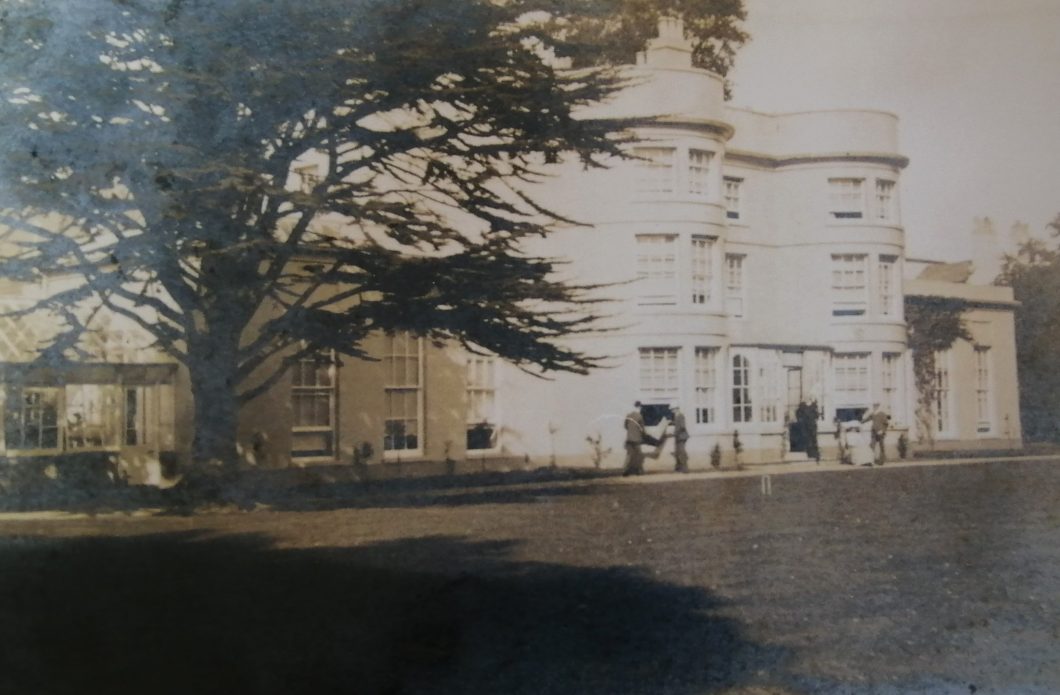
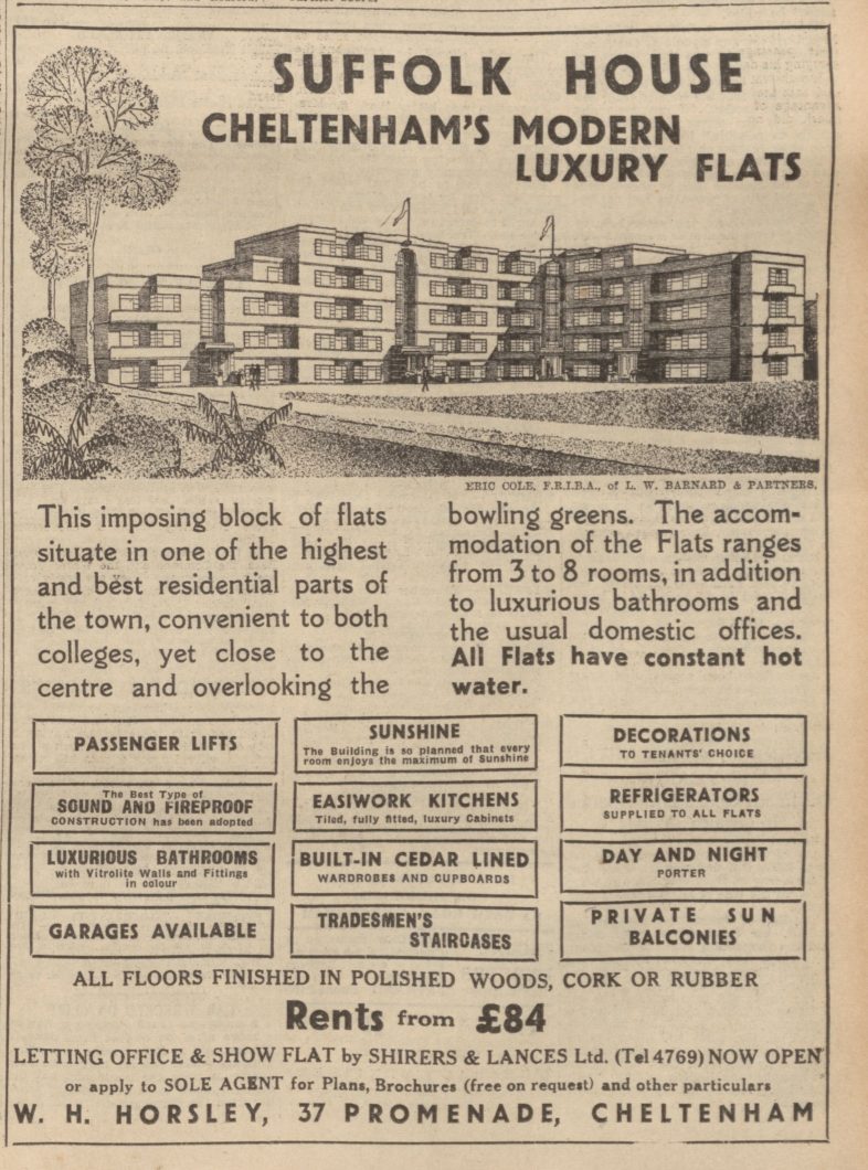
The original farm house was located to the north-west of Suffolk Square, where the Suffolk House flats stand today. In 1694 it was rebuilt and enlarged as ‘Gallypott Hall’. John Howard, 15th Earl of Suffolk, bought the house and surrounding fields in 1808 and proceeded to modernise the property, eventually renaming it Suffolk House.
The Regency Suffolk House came up for sale in 1936, when it was advertised as a family residence with 4 reception rooms, a billiards room, 10 bedrooms and 3 bathrooms. The gardens, measuring about 1 acre, were said to be tastefully laid out. The property failed to sell as a family home and was bought and redeveloped into an imposing block of flats, with several ‘art deco’ features. These were offered for sale from late 1937.
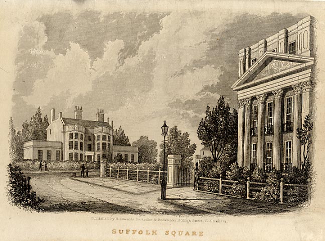
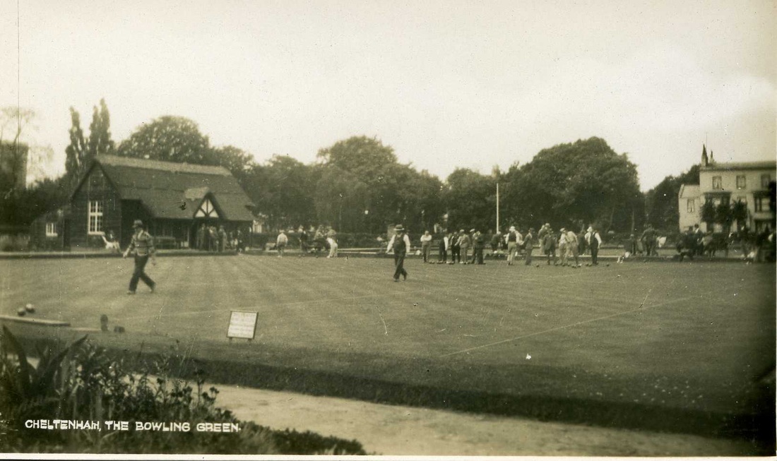
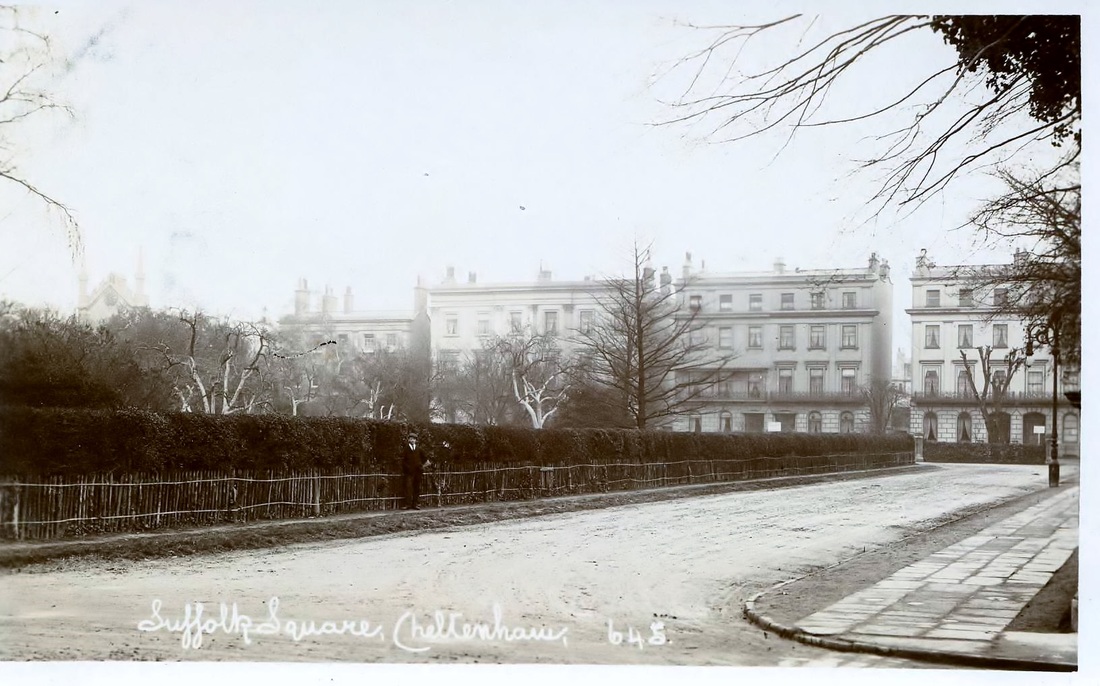
At the heart of this residential area Suffolk Square was developed from about 1823 by a local hotelier named James Fisher. Many of the buildings around the square were designed by the architect Edward Jenkins. The central garden belongs to Cheltenham Bowling Club, which was founded in 1883 but only relocated here from the Winter Gardens in 1918. Surprisingly, the square is labelled as the “Ashburne Bowling Green” in the Old Town Survey Map of 1855-57, however it seems likely that this annotation was added later. The land on which the green was laid out in 1917 was until then a market garden called Home Field; the name was probably a throwback to the time when it formed part of Gallipot Farm. The original rustic style club house, called the Unwin Pavilion, burned down in 1955 and was replaced by the current building.
St James’ church was built between 1825 -1830 in the Regency Gothic style by architects Edward Jenkins and J.B. Papworth.
To the north, the Suffolks are bounded by Back Montpellier Terrace, which is part of an old field path joining Sandford Road to the Gordon Lamp junction and on to Alstone via Lad’s Lane. As it was a public highway Henry Thompson, the developer of the Montpellier estate, could not build over it and instead backed his southernmost terrace in Montpellier right up to its line.
Despite its name Suffolk Parade was developed separately from Fisher’s Suffolk estate, by Henry Thompson, on the field called Home Acre (or Horne Acre Piece), which he acquired from John Delabere in 1807. It featured in the 1820 Post Office map of Cheltenham, before the development of Suffolk Square and Montpellier Villas, but there were gaps between the houses which must have been infilled at a later time. Number 26 (now The Copy Shop) may have been built as early as 1814 and the title deeds for number 25 indicate, in 1819, that a dwelling had also recently been built there. In 1818 Henry Thompson leased a parcel of land corresponding to the modern numbers 28-31 Suffolk Parade to a carpenter called Aaron Wills Gay, although at that time the street was unnamed.
Henry Thompson’s sons, Henry Teshmaker Thompson and Pearson Thompson, sold off parcels of land in the area of Suffolk Parade in the 1820s for future development. The terrace of houses on the eastern side of the street, at the southern end near to Suffolk Road, appears to have been completed first and was originally numbered from 1-13. When the northern end of Suffolk Parade was completed a little later it was numbered from 1-14 and we can imagine the confusion that this duplication may have caused! In 1893 the whole street was renumbered from 1-34, incorporating Suffolk Lodge (The Retreat) and St James’s Lodge (The Daffodil), which were previously without house numbers.
Suffolk Road was formerly known as Commercial Road and it was only partly built up by 1834. However this was already an ancient route from the Old Bath Road to Westal Green, across the open field system consisting of the Sandford and Westall fields.
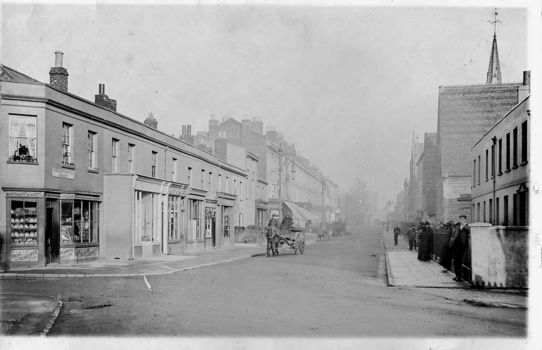
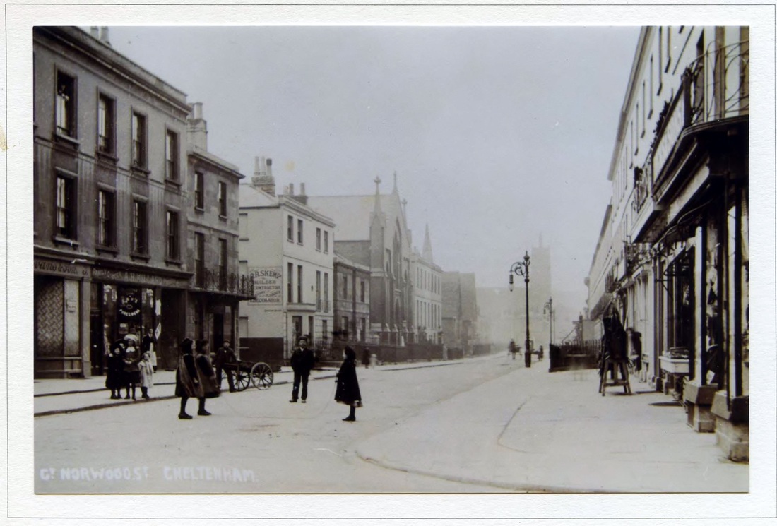
Great Norwood Street was laid out in around 1825 on land belonging to Henry Norwood Trye, the Lord of the Manor of Leckhampton. This had previously been part of the Westall open field, which was enclosed into smaller plots. The resulting field bordering the Suffolk Road was called the “Grattons” or “Grottens” and through here ran a spur line of the horse drawn railway, bringing stone from the Leckhampton quarries to Grotten’s Wharf. Great Norwood Street was later laid out along the route of the railway. Number 45, built by 1825, by a stone mason named Richard Allen, may have been the first house erected. The street was named on the Merrett map of 1834, when it was still only partially developed.
Research: Stuart Manton
With acknowledgement to the Historical Gazetteer of Cheltenham, by James Hodsdon, and Gloucestershire Archives.